What GeoAI Means for Mapping Pros
Learn how to extract building footprints from aerial imagery using U-Net, Grounding DINO, SAM, and Mask R-CNN.

GeoAI brings new precision to mapping
GeoAI is changing how we extract data from aerial imagery. It's fast. You can now build workflows to pull building footprints from high-resolution files without manual digitization, and that shift means the old way of tracing every line by hand is gone, replaced by automated spatial analysis that handles the heavy lifting for you. So it moves past traditional manual labor into a smarter, more efficient process.
First, set up your environment. That means installing specialized libraries and confirming your hardware can actually handle the workload, a step that often gets skipped but can save you hours of frustration later. But if you're running this in a cloud environment, make sure a GPU is ready. It makes a difference in speed. Don't skip that part, because without the right graphics processor, you'll watch your training times crawl while your costs climb. So check it now.
Building the processing pipeline
Your workflow starts by getting the right data. You download raster images and vector labels. Then you inspect them to ensure they align correctly. You want to verify spatial properties before you start cutting the data into smaller, manageable chips.
Once your data is ready, you move to the training phase.
- Configure your training settings like tile size and batch size.
- Train a U-Net model using a ResNet-34 encoder.
- Perform sliding-window inference on new scenes.
- Convert your predicted masks into usable vector polygons.
- Clean up the shapes using regularization.
Why model performance matters
You cannot just train a model and assume it works. You have to check the training curves. If you see your validation loss rising while your training loss falls, you are likely hitting overfitting. You might need to adjust your approach if your performance metrics are too low.
Pixel-wise metrics like IoU and F1 help you quantify success. But don't be fooled by that background IoU number. It's often inflated because the background covers so much area, which means a model can score impressively high on paper while completely missing the actual target that you care about in your project. Focus on the building-class IoU instead. That's where the truth lives. See if your model is really finding what you need.
Beyond standard segmentation
You can go further than training your own model from scratch. Some workflows now use zero-shot segmentation. This allows you to use text prompts to find buildings without training a custom model on your specific site.
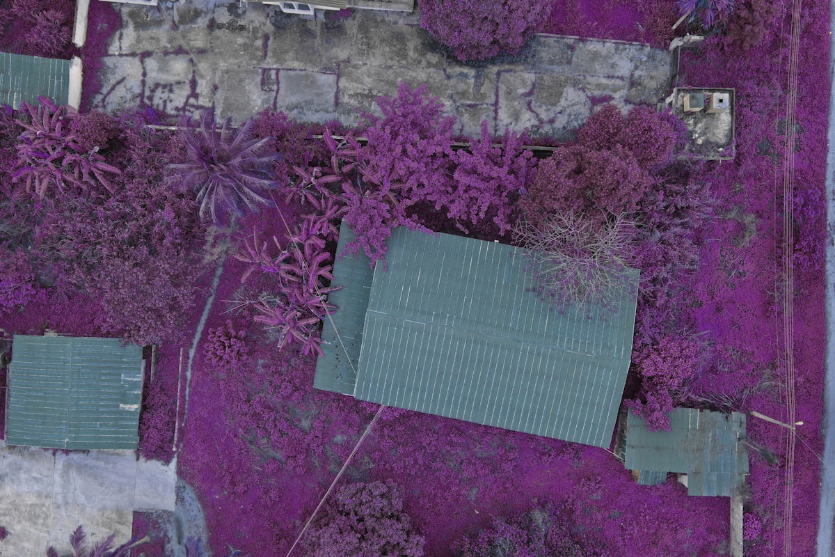
By using tools like Grounding DINO and SAM, you can segment images based on simple labels. You just provide text prompts such as building or rooftop. The system handles the rest.
Refining your final output
Raw output is rarely clean enough for professional use. But you can't just leave it as is. You must apply geometric regularization, a process that fixes jagged edges and irregular shapes, and that transforms a pixelated blob into a clean, squared-off building footprint. It's that simple.
Adding geometric properties like area and perimeter completes the process. So you get a clean set of polygons that you can actually use in your GIS projects, and it's a faster way to handle massive amounts of aerial imagery if you're working with thousands of tiles. That's the whole trick.
What this means for your daily work
If you're still tracing buildings by hand, you're working too hard. Stop doing that. And this automated path drastically cuts the manual effort and processing time you'd otherwise burn through, letting you redirect your energy toward analysis instead of grunt work. So you can apply it to real-world areas using imagery from sources like the Microsoft Planetary Computer, combined with labels from Overture Maps, which gives you a practical, ready-to-test workflow without any extra cleanup. It's that simple.
The transition to automated extraction is here. It is time to update your toolkit if you want to keep up with the volume of high-resolution data currently available.
Frequently Asked Questions
What is the primary benefit of using GeoAI in mapping workflows?
GeoAI brings new precision to mapping by automating the extraction of data from aerial imagery, such as building footprints, without manual digitization. This shift replaces the old method of tracing every line by hand with automated spatial analysis that handles the heavy lifting, making the process faster and more efficient.
Why is it important to have a GPU ready when running GeoAI workflows in a cloud environment?
The article states that having a GPU ready in a cloud environment makes a difference in speed. Without the right graphics processor, training times will crawl while costs climb, so checking this early can save hours of frustration.
How can you detect if your GeoAI model is overfitting during training?
You can detect overfitting by checking the training curves: if validation loss rises while training loss falls, you are likely hitting overfitting. In such cases, you may need to adjust your approach to improve performance.
What should you focus on when evaluating model performance in segmentation tasks?
You should focus on the building-class IoU rather than the background IoU, because the background IoU is often inflated since the background covers so much area. This means a model can score high on paper while missing the actual target, so the building-class IoU is where the truth lives.
Describe the process of refining raw model output into usable polygons for GIS projects.
Raw output is rarely clean, so you must apply geometric regularization to fix jagged edges and irregular shapes, transforming pixelated blobs into clean, squared-off building footprints. Then, adding geometric properties like area and perimeter completes the process, giving you a clean set of polygons usable in GIS projects.
Marcus Thorne covers the fast-moving field of artificial intelligence, with a particular interest in large language models, automation and the companies driving the technology forward. He aims to cut through the hype and explain what these systems can and cannot do.
💬 Comments (0)
No comments yet. Be the first!